
Highways
Interstate 65 – 18 miles
U.S. 421 – 7 miles
Indiana 218 – in Camden
Indiana 75 – in Camden
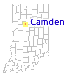
Maps
Region map
Area map with Hoosier Heartland Highway
Town Map
Carroll County Township maps
Other Carroll County maps
Rail
Camden- Flora Rail Corridor Commission
Winamac Southern Railroad
Indiana Rail System map (2012)
Air
Flora Municipal – 6 miles
Flora Municipal Airport has a 2,143 feet turf runway and is located 1/4 mile south of State Road 18 West. More information about the Flora Municipal Airport is available from Air Nav.
Delphi Municipal – 11 miles
The Delphi Municipal Airport has one hard surface runway and has easy access. More information about the Delphi Municipal Airport is available from Air Nav.
Logansport/Cass County Airport – 16 miles
http://www.airnav.com/airport/KGGP
Purdue University – 31 miles
http://www.purdue.edu/pat
http://www.airnav.com/airport/KLAF
Indianapolis INTL – 64 miles
http://www.indianapolisairport.com
http://www.airnav.com/airport/KIND